Skip to main content
Advanced Search Objects: results
Close
Refine Results
Show Only Public Domain
Format
Book
(7)
Date
to
Names
H. Belden & Co.
(6)
MacDonald, D. (Cartographer)
(1)
Rolph, Smith & Co.
(1)
Gorrell, Craig & Co.
(1)
Toronto : A.H. Gorrell & Co.
(1)
J.H. Beers & Co.
(1)
Subject
*
Atlases
(7)
Biographies
(7)
History
(7)
Maps
(7)
Real property
(3)
Collection
Baldwin Collection of Canadiana
(7)
Language
English
(7)
City, town or township
Ottawa
(1)
Toronto
(1)
Sort:
Relevance
Date (Older First)
Date (Newer First)
Title (A–Z)
Title (Z–A)
Last Updated (Ascending)
Last Updated (Descending)
List
Images
Table
/ 1
Advanced Search
Filters
Title
Names
Subject
Call Number / Accession Number
Date Range
to
Collection
All
Archives of Ontario
Arthur Conan Doyle Collection
Arts department
Baldwin Collection of Canadiana
Business, Science, and Technology department
Chinese Canadian Archive
City of Toronto Archives
Humanities and Social Sciences department
IBBY Collection for Young People with Disabilities
Languages and Literature department
Local History Collection, Annette branch
Local History Collection, Beaches branch
Local History Collection, Bloor/Gladstone branch
Local History Collection, Dufferin/St. Clair branch
Local History Collection, Gerrard/Ashdale branch
Local History Collection, Leaside branch
Local History Collection, North York Central Library branch
Local History Collection, Northern District branch
Local History Collection, Palmerston branch
Local History Collection, Parkdale branch
Local History Collection, Riverdale branch
Local History Collection, Sanderson branch
Local History Collection, Weston branch
Local History Collection, Wychwood branch
Merril Collection of Science Fiction, Speculation and Fantasy
Ontario History Quest
Osborne Collection of Early Children's Books
Special Collections in the Arts
Toronto Public Library Archives
Toronto Reference Library
Toronto Star Photograph Archive
zTEST
Formats
All
Artifact (an object in our collections)
Book
Ephemera
Fonds
Manuscript
Map
Photo Album
Picture
Language
All
Abenaki
Algonquin (other)
Athapascan
Beothuk
Catalan
Chinese
Chinook jargon
Cree
Croatian
Dakota
Danish
Dene Suline
Dené
Dogrib
Dutch
English
French
Gaelic, Scottish
German
Greek, Ancient (to 1453)
Greek, Modern (1453- )
Haida
Haudenosaunee
Hungarian
Innu-aimun
Inuktitut
Irish
Italian
Japanese
Language
Latin
Maliseet–Passamaquoddy
Miꞌkmaq
Mohawk
No linguistic content
Norwegian
Ojibwa
Oneida
Portugese
Russian
Seneca
Serbian
Siksika
Spanish
Swedish
Tsimshian
Ukrainian
Welsh
Wendat
Yiddish
Clear
7 for
Language
:
English
Biographies
Atlases
Clear All Filters
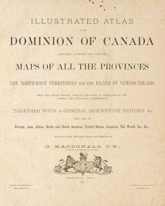
Illustrated atlas of the Dominion of Canada, containing authentic and complete maps of all the provinces, the North-west territories and the island of Newfoundland, from the latest official surveys and plans, by permission of the general and provincial governments, together with a general descriptive history, &c., also maps of Europe, Asia, Africa, North and South America, United States, Oceanica, The World, &c., &c.
1880
Illustrated atlas of the Dominion of Canada, containing authentic and complete maps of all the provinces, the North-west territories and the island of Newfoundland, from the latest official surveys and plans, by permission of the general and provincial governments, together with a general descriptive history, &c., also maps of Europe, Asia, Africa, North and South America, United States, Oceania, the world, etc. ... Lanark County
1880
Illustrated historical atlas of the county of Huron, Ont., compiled, drawn and published from personal examinations and surveys
1879
Illustrated atlas of the Dominion of Canada, containing authentic and complete maps of all the provinces, the North-West Territories and the island of Newfoundland, from the latest official surveys and plans, by permission of the general and provincial governments, together with a general descriptive history, &c., also maps of Europe, Asia, Africa, North and South America, United States, Oceania, the World, &c., &c.
1880
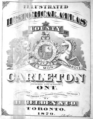
Illustrated historical atlas of the county of Carlton (including city of Ottawa), Ont
1879
Illustrated atlas of the Dominion of Canada, containing authentic and complete maps of all the Provinces, the North-West Territories and the Island of Newfoundland
1881
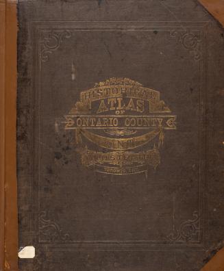
Illustrated historical atlas of the county of Ontario, Ont.
1877
/ 1
RDF
XML
JSON