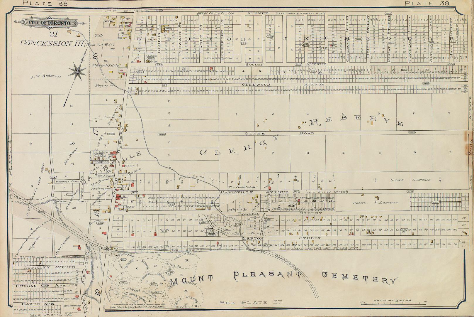

[Plate 38] Atlas of the city of Toronto and vicinity from special survey founded on registered plans and showing all building and lot numbers.
Date1893
Names
Chas. E. Goad, Ltd.
(publisher)
Goad, Charles E.
(author)
FormatMap
Subject
Medium
Dimensions45.5 x 142 cm
Language
CollectionBaldwin Collection of Canadiana
Usage Rights
Public Domain
(Learn More)
Object NumberATLAS-R-204
![[Plate 50. Key map for 1893 atlas] Atlas of the city of Toronto and vicinity from special survey founded on registered plans and showing all building and lot numbers.](/internal/media/dispatcher/1947661/thumbnail)
![[Plate 48. Key map for 1893 atlas] Atlas of the city of Toronto and vicinity from special survey founded on registered plans and showing all building and lot numbers.](/internal/media/dispatcher/2116661/thumbnail)
![[Plate 49. Key map for 1893 atlas] Atlas of the city of Toronto and vicinity from special survey founded on registered plans and showing all building and lot numbers.](/internal/media/dispatcher/2063019/thumbnail)
![[Plate 42] Atlas of the city of Toronto and vicinity from special survey founded on registered plans and showing all building and lot numbers.](/internal/media/dispatcher/1947551/thumbnail)
![[Plate 35] Atlas of the city of Toronto and vicinity from special survey founded on registered plans and showing all building and lot numbers.](/internal/media/dispatcher/2117712/thumbnail)
![[Plate 39] Atlas of the city of Toronto and vicinity from special survey founded on registered plans and showing all building and lot numbers.](/internal/media/dispatcher/1951307/thumbnail)
![[Plate 41] Atlas of the city of Toronto and vicinity from special survey founded on registered plans and showing all building and lot numbers.](/internal/media/dispatcher/2062984/thumbnail)
![[Plate 49] Atlas of the city of Toronto and vicinity from special survey founded on registered plans and showing all building and lot numbers.](/internal/media/dispatcher/2117710/thumbnail)
![[Plate 12] Atlas of the city of Toronto and vicinity from special survey founded on registered plans and showing all building and lot numbers.](/internal/media/dispatcher/1975819/thumbnail)
![[Plate 13] Atlas of the city of Toronto and vicinity from special survey founded on registered plans and showing all building and lot numbers.](/internal/media/dispatcher/1951285/thumbnail)