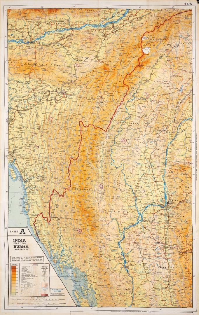

Sheet A India (Part Of) Burma (North West) : Sheet B Burma (North East) Siam (Thailand) (North) French Indo China (Part Of) China (Part Of)
DateApproximately 1944
Names
Great Britain. MI9
(cartographer)
Great Britain. MI9
(subject)
Great Britain. War Office
(cartographer)
Great Britain. War Office
(subject)
FormatMap
NotesA facsimile copy of this map is available to the public in the Humanities & Social Sciences Department in Map Cabinet 25, Asia Drawer. The original map can be viewed upon request, please inquire at the information desk in the Humanities & Social Sciences Department. Double sided map. This map is one of a set of maps produced on silk (or rayon) by MI9 for escape and operational purposes for RAF pilots. Each map in the series is assigned number 44 followed by a letter. A detailed history of these maps can be found on the British Library website: https://www.bl.uk/maps/articles/escape-and-evasion-maps-of-world-war-ii
Medium
Dimensions91 cm x 58 cm (35 13/16 in. x 22 13/16 in.)
Scale1:1,000,000
Language
ProvenanceAnonymous donor
Usage Rights
Public Domain
(Learn More)
Object Number912-591-G67

Great Britain. MI9
Approximately 1944

![Evaculation trains like this have been a familiar feature in China during the recent Japanese advance which has compelled U.S. fliers to abandon airfield after airfield. [Incomplete]](/internal/media/dispatcher/1906233/thumbnail)

Toronto Star (Firm)
10/2/1944

![Revolutionary! exclaimed a supervisor, at women working on parts of fuselage, as Valida igle and Jean Neil are, rivetting main piping [Incomplete]](/internal/media/dispatcher/1837196/thumbnail)