Skip to main content
Search
Objects
(181,123)
People
(41,122)
Close
Refine Results
Show Only Public Domain
Format
*
Map
(2)
Date
to
Names
Unknown
(2)
Rust, C. H. (Charles Henry), 1852-1927
(1)
Subject
Maps
(2)
Roads
(2)
Election districts
(1)
Land subdivision
(1)
Maps and surveys
(1)
Railroads
(1)
Collection
Baldwin Collection of Canadiana
(2)
Language
English
(2)
City, town or township
Toronto
(2)
Neighbourhood
East York
(1)
High Park
(1)
Lambton
(1)
Seaton Village
(1)
University
(1)
Weston
(1)
Yorkville
(1)
North-south street
Bathurst Street
(1)
Yonge Street
(1)
East-west street
Davenport Road
(1)
Dundas Street East
(1)
Dundas Street West
(1)
Kingston Road
(1)
Sort:
Relevance
Date (Older First)
Date (Newer First)
Title (A–Z)
Title (Z–A)
Last Updated (Ascending)
Last Updated (Descending)
List
Images
Table
/ 1
Filters
2 results for
*
Result type
Objects
People
Map
Etobicoke (Ont.)
Clear All Filters
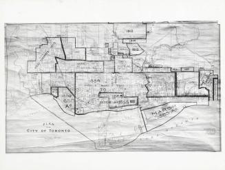
Plan of the City of Toronto, with additions up to 1925
1930 circa
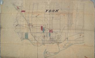
York
Approximately 1872
/ 1
RDF
XML
JSON