Skip to main content
Search
Objects
(181,123)
People
(41,122)
Close
Refine Results
Show Only Public Domain
Format
*
Map
(3)
Date
to
Names
Tardieu, P. F.
(2)
Captain in his majesties navy
(1)
Jefferys, Thomas, -1771
(1)
Thomas Kensett
(1)
Kensett, Thomas Doolittle, A.
(1)
Thomas Jefferys
(1)
Subject
Maps
(2)
Boundaries
(1)
First Nations
(1)
History
(1)
Indians of North America
(1)
Québec Campaign, 1759
(1)
War of 1812
(1)
Collection
Baldwin Collection of Canadiana
(3)
Language
English
(2)
French
(1)
Sort:
Relevance
Date (Older First)
Date (Newer First)
Title (A–Z)
Title (Z–A)
Last Updated (Ascending)
Last Updated (Descending)
List
Images
Table
/ 1
Filters
3 results for
*
Result type
Objects
People
Map
Ontario||Québec
Clear All Filters
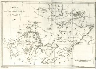
Carte des pays situes à l'ouest du Canada 1791
1794
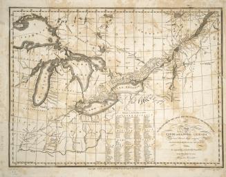
To the officers of the Army and the citizens of the United States This map of Upper and Lower Canada and United States contigious Contracted from the (...)
1812
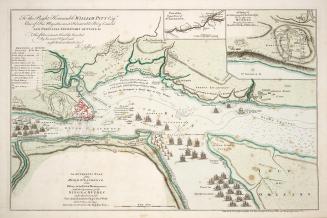
An authentic plan of the River St
1759
/ 1
RDF
XML
JSON