Skip to main content
Search
Objects
(181,123)
People
(41,122)
Close
Refine Results
Show Only Public Domain
Format
Map
(74)
Manuscript
(3)
Date
to
Names
Chewitt, William, 1753-1849
(13)
Smyth, David William, Sir, 1764-1837
(11)
Unknown
(9)
Browne, John Ownsworth, 1808-1881
(5)
Denison, George T. (George Taylor), 1839-1925
(5)
Howard, John George, 1803-1890
(5)
J. Simpson
(4)
Russell, Peter, 1733-1808
(4)
Dennis, John Stoughton, 1820-1885
(4)
Robertson, J. Ross (John Ross), 1841-1918
(4)
Load all
Subject
Maps
(71)
Land subdivision
(37)
Maps and surveys
(23)
Estates
(5)
Roads
(5)
Harbour
(4)
Military reservations
(4)
Forts and fortifications
(3)
History
(3)
Homes and haunts
(3)
Load all
Collection
Baldwin Collection of Canadiana
(77)
Language
English
(74)
French
(3)
Building, monument or park
Toronto Harbour
(2)
Fort Frontenac
(1)
Fort George
(1)
Provincial Lunatic Asylum
(1)
City, town or township
Toronto
(52)
Hamilton
(3)
Ameliasburgh (Ont.: Township)
(2)
King (Ont. : Township)
(2)
Vaughan
(2)
Aurora
(1)
Chicoutimi
(1)
Kingston
(1)
Markham
(1)
Newmarket
(1)
Load all
Neighbourhood
Harbour
(14)
King-Spadina
(9)
St. Lawrence
(8)
Railway Lands
(7)
Financial District
(6)
Garrison
(4)
Kensington-Grange
(4)
Downtown
(3)
Dufferin Grove-Bickford Park
(3)
Trinity Bellwoods
(3)
Load all
North-south street
Dovercourt Road
(3)
Bathurst Street
(2)
Peter Street
(2)
Rusholme Road
(2)
Spadina Avenue
(2)
Carlaw Avenue
(1)
John Street
(1)
Leslie Street
(1)
Lippincott Street
(1)
Ossington Avenue
(1)
Load all
East-west street
Bloor Street West
(3)
College Street
(3)
Queen Street West
(3)
Dundas Street West
(2)
Kingston Road
(2)
Adelaide Street West
(1)
Davenport Road
(1)
Dundas Street East
(1)
Front Street West
(1)
Harbord Street
(1)
Load all
Sort:
Relevance
Date (Older First)
Date (Newer First)
Title (A–Z)
Title (Z–A)
Last Updated (Ascending)
Last Updated (Descending)
List
Images
Table
/ 4
Next
Filters
77 results for
*
Result type
Objects
People
Manuscript maps
Clear All Filters
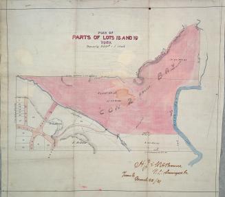
Plan of parts of lots 18 and 19 York
1881
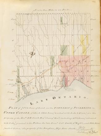
Plan of 7800 acres of land in the township of Pickering in Upper Canada of which 6600 acres property of D
1802
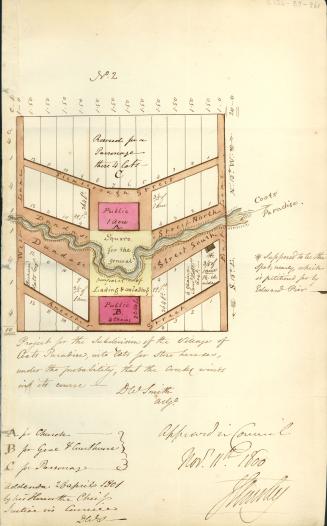
Project for the subdivision of the village of Coots Paradise into lots for store houses under the probability that the Creek winding its course
1800
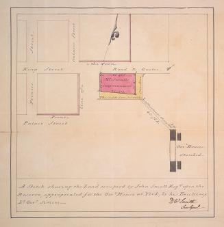
A sketch shewing the land occupied by John Small Esqr
1802
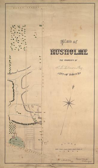
Plan of Rusholme the property of G.T. Denison Esq. city of Toronto
1862
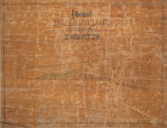
Plan of building lots abutting upon Queen Street East in the city of Toronto
1850
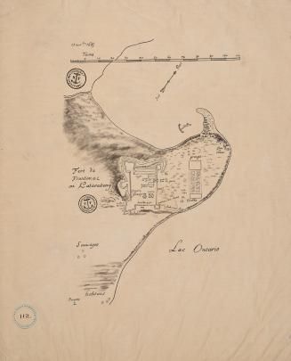
Fort Frontenac ou Katarakouy (November 13 1685)
Approximately 1910
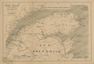
Lower Canada from L'Islet to Gaspé
1861
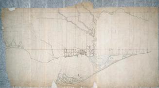
Plan submitted by Order of His Honor the President for the enlargement of York.
1797
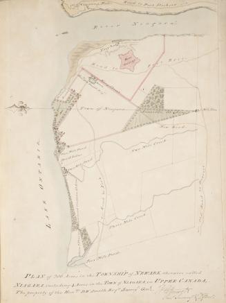
Plan of 206 acres in the Township of Newark otherwise called Niagara including 4 acres in the town of Niagara in Upper Canada, the property of the Hon. D W Smith Esqre. Surveyr. Genl.
1802
Toronto
1837
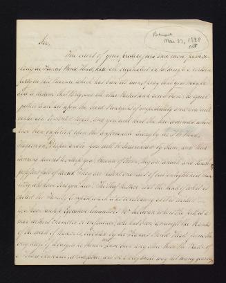
Letter to George Arthur, 27 Mar
1838-03-27
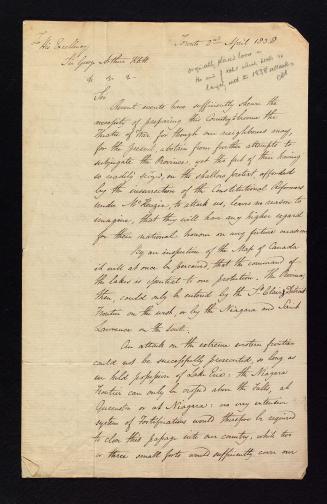
Letter from J. S. Macaulay to George Arthur, 2 Apr. 1838
1838-04-02
Toronto
Approximately 1872
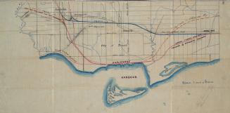
Results of observations in Ashbridge's Bay made by E.B. Shuttleworth in May 1884
1884
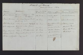
Board of Health. Record of Cases, June 22, 1832
1832-06-22
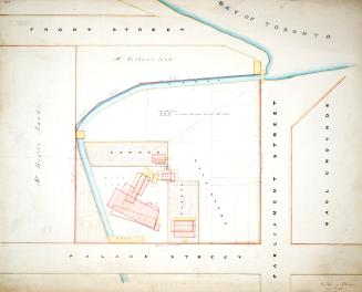
Plan of property belonging to Enoch Turner, Esq
1850-06-01
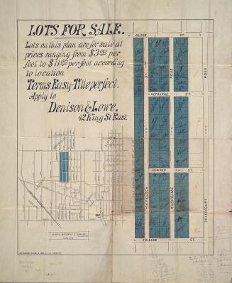
Plan of lots for sale in Dovercourt
1883
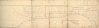
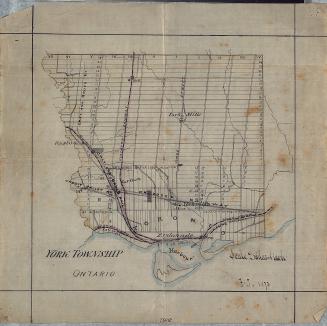
York Township, Ontario
1873
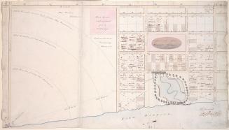
His Honor the Presdt approval of the town plot of York. 2nd addition
1798
/ 4
Next
RDF
XML
JSON